Recent Updates

Introduction To ilam district


Ilam
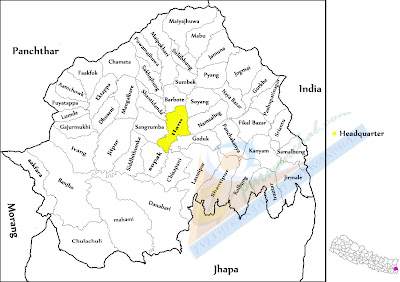
Ilam distric is one of the seventy-five districts of Nepal, The district, with the town of Ilam as its district headquarters, covers an area of 1,703 km² and has a population (2001) of 282,806. It is about 600 km from Kathmandu. The highest point is Sandakpur with an elevation of 3000m. Ilam attracts many researchers who come to study rare birds and tea estate. Ilam stretches from the Terai belt to the upper hilly belt of this Himalayan nation.
The name Ilam is derived from the Limbu language in which "Ii" means twisted and "Lam" means road. Ilam was one of the ten self ruling states of Limbuwan before the unification of Nepal, its ruler King Hangshu Phuba Lingdom of Lingdom dynasty ruled Ilam as a confederate state of Limbuwan until 1813 AD. The treaty between the other Limbuwan states and the King of Gorkha (Gorkha-Limbuwan Treaty of 1774 AD) and the conflict of Gorkha and Sikkim led to the unification of Ilam with Gorkha. Ilam was the last of the ten kingdoms of Limbuwan to join the union of Nepal. The King of Gorkha gave the ruler of Ilam full autonomy to rule and the right of Kipat. Ilam was an independent Limbu kingdom until 1813 CE/1869 BS.
Ilam is today famous in the world for tea production. Its ILAM TEA is very famous and is exported to many parts of Europe. The main source of income in this district is tea, cardamom, milk, ginger and potato.
This place also has a religious importance. The devi temples have a great importance attached to them and many people come here just for pilgrimage.
The major attraction of Ilam is the 9-cornered Mai Pokhari lake. Also known as the abode of the goddess lots of tourists as well as Nepalese people come to visit this lake. Mai river and its four tributaries also emerge in Ilam district. The famous Mane Bhanjyang (Mane pass) connects Ilam with Darjeeling district of West Bengal, India.
4 comments

Pathivara Devi Temple - Taplejung District

pathivara devi temple

One of the major attractions of Taplejung is the Pathivari devi Temple. This little known region attracts tourists seeking spiritual fulfillment and blessings from the powerful  Pathivari devi . Hindus as well as Buddhists reach the temple for celebrations during special occasions. The trek to Pathivari devi (3794 m) combined with the natural and cultural experiences of the region make the visit a unique exhilarating experience. It takes a single  day to reach the temple of Pathivara on foot from Taplejung Bazaar. On the way to the temple one can find many species of Rhododendron (लालीगुराँस). The shrine of the Pathibhara Devi temple is located on a mountain at 3794 meters in the Far East of Nepal. The temple is holy for Hindu's as well as Buddhists.
3 comments

Cho Oyu 8201 m (The Sixth highest peak in the world)

cho oyu

Unlike other attempts, the successful expedition to Cho Oyu had its origins in very simple circumstances. Cho Oyu is the easiest mountain to climb among the 8000 meters mountain. Cho Oyu lies 20 Km West of Everest, at the border between China and Nepal.  In Tibetan, Cho Oyu means “Turquoise Goddess” .
The first attempt to this mountain a was made by an expedition supported by a Joint Himalayan Committee of Great Britain as preparation for an attempt to Mount Everest the following year with Eric Shipton as team leader. Expedition also include Edmund Hillary, George Lowe, Charles Evants and Tom Bourdilon, but technical difficulties at ice cliff above 6650m forced them to give up a climb.
Finally on 19th October 1954 Tichy, Joseph Jochler and Pasang Dawa Lama climbed via the north ridge. The first Nepali to climb it was Ang Phuri Sherpa on 29th April  1987.
2 comments

Namche Bazaar - Solukhumbu District

namche bazar
Namche Bazaar is a village and Village Development Committee (Namche) in Solukhumbu District in the Sagarmatha Zone of  Nepal in Eastern Development Region. It is located within the Khumbu region at 3,440 metres (11,286 ft) (the low point that is), populating the sides of a hill. Namche is the main trading center for the Khumbu region with many Nepalese officials, a police check, post and a bank.
On a hill overlooking Namche Bazaar is the Syangboche Airport (3,750m / 12,303 ft). Which is the highest airfield in Nepal. Namche Bazaar is popular with trekkers in the Khumbu region, especially for altitude acclimatization, and is the gateway to the high Himalaya. The town has a number of lodgings and stores catering to the needs of visitors as well as a number of internet cafés, making it one of the few places in the region where trekkers can access the Internet.
On Saturday mornings, a weekly market is held in the center of the village while there may also be a daily Tibetan market where clothing and cheap Chinese consumer goods tend to be the main articles for sale.
1 comments

Lukla Bazar- Solukhumbu District


Lukla, a town in the khumbu region of the Solukhumbu District  in the Sagarmatha Zone of eastern Nepal. Which is situated at 2,860 metres (9,383 ft) from the sea level, it is a popular place for visitors to the Himalayas near Mount Everest to arrive. Although Lukla means place with many goats and sheep, few are found in the area these days.
Lukla contains a small airport servicing the region, and a variety of shops and lodges catering to tourists and trekkers, providing western-style meals and trail supplies.
From Lukla, most trekkers will take two days to reach Namche Bazaar, both an interesting village and an altitude acclimatization stop for those continuing on
Lukla is served by the Tenzing-Hillary Airport. Weather permitting, twin-engined Dornier and Twin Otters make frequent daylight flights between Lukla and Kathmandu. Lukla Airport has a very short and steep airstrip, often compounded by hazardous weather, resulting in several fatal accidents. It has been called the most dangerous airport in the world
39 comments
 
Contact : info@rameskhadka.com.np
Copyright © 2015. EVERYTHING ABOUT PURWANCHAL || Eastern Development Region Nepal - All Rights Reserved
Website Designed By Ramesh Khadka
=========================================================================================================================================