Recent Updates

Makalu Barun National Park

Total Area : 1500 sq km.
Buffer Zone : 830 sq km.
Activities : Trekking, Mountaineering
Accommodation : Resort hotels, Lodges, Camping
Access : Fly to Tumlingtar from kathmandu (40 minutes and six days walk)
Best Season : Oct-Nov and Mar-April
                       Apr-May (hot at lower elevations)
                       Jun-Sep (monsoon)
Prak Headquarter : Seduwa, Sankhuwasava
Contact : 029-560136

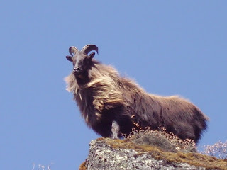
Thar
The park spreads over the districts of Sankhuwasava and Solukhumbu in the northeast Nepal. One of the prime attraction for visitors to the park is to experiance the unique Himalayan bio-diversity. The vegetation rangees from sub tropical froests to sub alpine and alpine as altitude increases. The park boasts of 48 spices of orchids, 87 spices of medical herbs, 25 of Nepal's 30 varieties of rhododendron, 19 bamboo spices, 15 oak spicies, 48 spicies of primerose and 86 spices of fodder trees. The park also offers bird watching oppertunities with its 400 spicies of birds, including the rare spotted wren babbler and olive ground warbler. Wild life include the indangered red panda, snow leopard, Himalayan black bear, clouded leopard, ghoral, thar, wild boar, barking deer, Himalayan marmot, weasel, langur monkey and serow. Arun river that flows through the park has 84 varieties of fish including salmon.
1 comments

Sagarmatha National Park

Total Area : 1148 sq km.
Buffer Zone : 275 sq km.
Activities : Trekking, Mountaineering, Experiance of sherpa culture
Accommodation : Resort hotels, Lodges, Camping
Access : Fly to Lukla which is 30 minutes by air from kathmandu.
Best Season : Oct-Nov and Mar-May
                        Dec-Feb (Snow, daytime temperature 5 degrees Celcius)
                        Jan-Sep ( Rainy)
Prak Headquarter : Mendalphu, Namche Bazar, Solukhumbu
Contact : 038-626043
Sagarmatha National Park

The prime attraction of Sagarmatha National Park is Mt. Everest, the highest peak of he world. The park was added to the list of the world haritage site in 1979. The park, a part of the himalayan ecological Zone, has several other prominent peaks most of which are above 6000 metres with most of the park above 3000 metres, Sagarmatha is full of rugged terrain with deep gorges, glaciers and huge rocks. With its Himalayan terrain and its unique culture, the park offers a blend of natural and cultural tourist products here. The vegetation at lower elevation is dominated by pine and hemlock forests, while above 3500 m the forest is dominated with silver fir, birch, rhododendron, and juniper trees. During spring and monsoon the varieties of rhododendron flowers are seen. The common wildlife in the park are Himalayan thar, ghoral, mrarelyusk deer, pikka (mouse hare), weasel, jackal. Other rarely seen animals are Himalayan black bear, wolf, lynx, and snow leopard.
Snow Leopard 
Birds inhabiting the park are the impeyan pheasant (Danphe), blood pheasant, red-billed chough, yellow-billed chough, snow cock, snow pigeon, Himalayan griffon, and lammergeyer. The national park also showcases the cultural trophies with the warm sherpa hospitality and its many monasteries and cultural landmarks. 
0 comments

Adventures at Purwanchal

rafting
Nepal is one of the best country for adventure destination. An adventurer's delight, Nepal offers a plethora of outdoor activities, from paragliding near the mountains to waiting for the Royal Bengal tiger in Chitwan's wild. Nepal also offers Bungy jumping above the wild waters of River Bhote Koshi
Among the development region, Eastern development region is the most adventure destination in Nepal. Adventure tourism in (Eastern Development Region) Purwanchal dates back to the early attempts to ascend world's highest peak Mt. Everest fifty years ago. Trekking and mountain climbing are still the most popular sport among visitors. Rafting on Tamor river, Trisuli river and Bhote Koshi is equally popular. Jungle safari in the Koshi Tappu in Terai is preferred by visitors interested to see Purwanchal's rare varieties of animals and birds.
1 comments

Taplejung - Introduction

Taplejung District: ( ताप्लेजुङ जिल्ला) a part of Mechi Zone, is one of seventy-five districts of Nepal, a landlocked country of South Asia. Taplejung (Fungling) is the headquarter of all its districts. It covers an area of 3,646 km² and has a population (2001) of 134,698.
                          The name Taplejung is originated from the words "Taple" and "Jung". Taple was the medieval Limbu King who used to rule the area and "Jung" in Limbu language means Fort. Literally, Taplejung means Fort of King Taple.


           Taplejung is located in North Eastern Nepal; the Tamor River flo
ws through the district. The area is famous for its proximity to Kanchenjunga, the third highest mountain in the world. Taplejung has an airstrip with commercial flights to Biratnagar and Kathmandu. A road connects the district headquarters with the Terai plains. Most of the populations are involved in agriculture, and the vegetation zones range from sub-tropical to temperate forests, alpine meadows, and snow, and ice.
Taplejung is one of the most beautiful areas in eastern Nepal, with a spectacular landscape, Himalayan peaks of heights above 7000 meters and a wide range of flora and fauna. Mt. Kanchanjunga (8586 m), the world's third largest peak, lies in this region. Alpine grassland, rocky out crops, dense temperate and subtropical forests, and no river valleys make up the region. Taplejung occupies an area ranging from 670 meters to 8586 meters (Mt. Kanchanjunga) above sea level.   
          
Taplejung is located in North Eastern Nepal; the Tamor River flows through the district. The area is famous for its proximity to Kanchenjunga, the third highest mountain in the world. Taplejung has an airstrip with commercial flights to Biratnagar and Kathmandu. A road connects the district headquarters with the Terai plains. Most of the populations are involved in agriculture, and the vegetation zones range from sub-tropical to temperate forests, alpine meadows, and snow, and ice.
Taplejung is one of the most beautiful areas in eastern Nepal, with a spectacular landscape, Himalayan peaks of heights above 7000 meters and a wide range of flora and fauna. Mt. Kanchanjunga (8586 m), the world's third largest peak, lies in this region. Alpine grassland, rocky out crops, dense temperate and subtropical forests, and no river valleys make up the region. Taplejung occupies an area ranging from 670 meters to 8586 meters (Mt. Kanchanjunga) above sea level.     
2 comments

Introduction to Bhojpur District

Bhojpur Bazar
Bhojpur district (भोजपुर जिल्ला), a part of Kosi Zone, is one of the seventy five districts of Nepal, a landlocked   country in South Asia. The district, with Bhojpur as its district headquarters, covers an area of 1,507 km² and has a population (2001) of 203,018. Traditionally, the inhabitants of this area have been the indigenous Rai ethnic group; the Newar ethnic group being the main people in the Bhojpur town. Bhojpur forms part of Majh Kirat/Kirant (Middle Kirat). It is one of the richest districts in Nepal in biodiversity.
To the northern part of this district lies the beautiful small city of Dingla. Various hill castes, Brahmin (bahun in Nepali), Kshetriya(Chhettri in Nepali), and ethnic groups like Rai reside within this beautiful area. This is the place where rudraksha trees are grown naturally in the forest as well as individually on people's land. The religious leader, women's rights activist and poet Yogmaya Neupane was born in 1860 in Dingla.
Champe is the other small town where people from surrounding villages come and sell their products. This happens every 15 days and is called Hatiya.
Balankha (Walangkha) is one of the growing towns in the southwest area of Bhojpur. Another town Ghoretar, southeast of Bhojpur, has been a center point of trade, education and administration for a long time. It is famous as Hatuwa Gadi "a powerful Fort of Kirat king Sunahang" in Kirat history.
Balankha borders with neighboring Khotang district's Bopung village. Balankha is slowly emerging as another hub of education, communication, health and trade. The most distinctive thing about Balankha is its famous Chhongkha Chandi celebration. It is the Kirat Rai festival when Rais go to 'Chandi Than' at Dammarkhu village of Khotang (across the river Buwa Khola), pray for good harvest and rain. Then they flock back to the open space of Chandi bazar to dance and celebrate with great joy
4 comments
 
Contact : info@rameskhadka.com.np
Copyright © 2015. EVERYTHING ABOUT PURWANCHAL || Eastern Development Region Nepal - All Rights Reserved
Website Designed By Ramesh Khadka
=========================================================================================================================================