Recent Updates

Khotang District

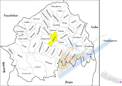
map-of-khotang-district
Khotang District is a part of Sagarmatha Zone in eastern part of Nepal, is one of the seventy-five districts of Nepal. The district, with Diktel as its district headquarters, covers an area of 1,591 km². Khotang is part of the area traditionally called Majh Kirat/Kirant (middle Kirat), home to indigenous ethnic Kirat Rai people. Apart from Rais, other ethnic groups and hill castes live in Khotang.

Khotang district is not only rich in nature and cultural heritage but also has significant religious values in the lives of people living in Nepal. Apart from being in a hill region, there are also certain difficulties of transportation on the way to Khotang, however, that does not affect the high religious importance the place holds. There are various temples and religious sites in Khotang district. Halesi Mahadev is one of the most famous religious place in Khotang district.

Halesi Mahadev
halesi-mahadev
The sacred cave that houses the two feet tall Shiva Linga is one of the popular and most important religious destination not only in Khotang but also in Nepal. The cave popular by the name of Halesi Mahadev has two pillars to the north side of the Shiva Linga that stands very close to each other making a narrow pass. It is believed that the sinners cannot pass through this narrow passage and only a confession from them shall grant them a passage through. Every year, thousands of devotees come here to worship the lord with a belief that he could give knowledge, wisdom to the children and prosperity to the poor.


26 comments

Trekking


Trekking is the ultimate destination for trekking enthusiast offering a myriad of possibilities from a short and easy to the demanding challenges of the snowy peaks. Easy, moderate or rigorous there is some thing for every one. Nepal has aptly called "A Trekkers Paradise" as her Terrain Mountains, hills and terai offers some of the most spectacular trekking routes in the world. The immense contrasts in altitudes and climates found here support an equally spectacular mix of lifestyles, vegetation and wild life.


Trekking in Nepal is as much a cultural experience as a Himalayan adventure. In the shadows and foothills of the icy pinnacles of the Himalayans, one passes picturesque charming villages inhabited by diverse ethnic groups. Treks vary from expeditions, high altitude treks to simple easy paced walks.
4 comments

Kanyam Tea Estate

KanyamThe Kanyam tea estate is situated at a height around 6,000 ft above sea level that is the highest in ILam district &. was first planted under the technical collaboration of the British government. Kanyam's first foundation was planted by the Late King Birendra with a kind feeling, depth &. vision to encourage the tea sector in Nepal which is located very near to mountain Kanchanjanga.

The Kanyam tea garden consists of approx. 240 hectares of which tea is planted on 200 hectares &. produces around 125 thousand Kgs. of some of the most exquisite Orthodox tea.

The Kanyam tea factory is located at an altitude of 5500 ft. above sea level
The Darjeeling hill plantations is about 2 Km from the Kanyam tea estate &. is similarly conducive to the kind of environment required to grow tea with a subtle brew &. flavor loved by all.

Climatic conditions are so parallel that the thick Cotton Clouds seen over ILam &. Darjeeling literally cross each other sparking off the same mountain winds &. rain that clean the tea gardens situated in these areas.

5 comments

Rafting Adventure

Rafting
Rafting is one of the most exciting ways of exploring Purwanchal. Rafting trips are usually planned in the dry seasons from October through mid-December and March through early May. The rivers such as Tamor, Arun are opened by the government for commercial rafting. Since safety is utmost importance, choosing a well-reputed rafting company is recommended.
1 comments

पाँचथर जिल्ला

Panchthar Districtपाँचथर जिल्ला  मेची अञ्चलको पूर्वी पहाडी जिल्ला हो। यो जिल्ला समूद्र सतहबाट ३८३ मिटर, जिल्लाको दक्षिण तमोर बगर देखि ४,५७५ मिटर फलैचा गाविसको उच्च भागसम्म अवस्थित छ। नेपाल अधिराज्यको पूर्वी सिमानामा रहेको मेची अञ्चलमा पर्ने यो जिल्ला उत्तर(दक्षिण फैलिई पल्लो किराँतको नामले पनि प्रसिद्ध छ। प्राचिन समयको लिम्बुवान क्षेत्रको केन्द्रबिन्दुको रूपमा रहेको यस जिल्लाको सदरमुकाम फिदिममा दश लिम्बुवान क्षेत्रका राजाहरू ९फेदेन०ले संयुक्त रूपमा सभा गरी सामुहिक रूपले महत्वपूर्ण विषयहरू यहाँ स्थित आम्बे पोजोमा भन्ने तिर्थस्थलमा जम्मा भई सभा चुम्लुङ्ग द्वारा निर्णय गर्ने परम्परा भएको देखिन्छ ।

यस जिल्लाको नामाकरण कसरी भयो भन्ने स्पष्ट कुनै तार्किक आधार नदेखिए पनि सोधकर्ताहरूका अनुसार पाँचथर शब्द ूपान्थरथुमुू बाट आएको हो र सो ूपान्थरथुमू शब्द ूपान्थरुू र ूथुमू मिलेर बनेको शब्द हो। पान्थरुको अर्थ कुरा थामेको ९ब्नचभभम०, थुमको अर्थ इलाका वा किल्ला ९म्ष्कतचष्अत० हो। यसै शब्दार्थका आधारमा नेपाल एकीकरण पश्चात यहाँका चलिआएका धर्म, संस्कृति र रीतिरिवाजका बारेमा ुफेदेनुमा ुचुम्लुङ्गुबसी सभाले तय गरेका निर्णय नेपाल सरकारमा पेश हुँदा तत्कालिन राजाले त्यसलाई स्वीकृती दिएपछि लिम्बुवान क्षेत्रको रितिरिवाज सम्बन्धि कुरामिलेको ९पान्थरु० हुँदा यस क्षेत्रकै नाम पान्थरु रहेको हो भन्ने मत पाइएता पनि किराँत इतिहासका पुराना साहित्यहरूमा इस्वी सम्वत ५५० ताकाको बर्णन
गर्ने क्रममा नै पान्थर शब्दको प्रयोग भएको पाइन्छ।

पूर्वमा भारतको सिक्किम र दार्जिलिङ्ग , पश्चिममा तेह्रथुम र धनकुटा जिल्ला, उतरमा ताप्लेजुङ जिल्ला र दक्षिणमा इलाम र मोरङ जिल्ला सम्म फैलिएको यस जिल्लाको कुल क्षेत्रफल १,२४१ वर्ग किलोमिटर रहेको छ भने यो जिल्लाको सदरमुकाम फिदिम हो ।

काबेली, तिम्बुपोखरी, महादेव स्थान, जोरपोखरी, आगेजुङ्ग गुम्बा, पाथीभरा देवीस्थान याङनाम, सिद्ध देवीस्थान, गढी मन्दिर, थाक्ले मन्दिर, किराँतहरूको प्रसिद्ध लुब्रेकुटी मन्दिर, महागुरु फाल्गुनन्दको मन्दिर आदि यहाँका प्रमुख धार्मिक महत्वका स्थानहरु हुन् ।

1 comments

सङ्खुवासभा जिल्ला

Map of Sankhuwasava Districtसङ्खुवासभा पूर्वाञ्चल विकास क्षेत्रको कोशी अञ्चलमा अवस्थित हिमाली भेगको एक दुर्गम जिल्ला हो। यो जिल्ला पूर्वमा ताप्लेजुङ र तेह्रथुम, पश्चिममासोलुखुम्बू र भोजपुर जिल्ला, उत्तरमा चीनको तिब्बत र दक्षिणमा तेह्रथुम र धनकुटा जिल्लाको चौबन्दीमा रहेको छ। यसले नेपालको कुल क्षेत्रफलको २।३६५, पूर्वाञ्चल विकास क्षेत्रको १२।१९५ र कोशी अञ्चलको ३५।६८५ भू(भाग ओगटेको छ। समुन्द्री सतहदेखि ४५७ मिटर ९संसारको सबैभन्दा होचो अरुण उपत्यका देखि विश्वको पाँचौं अग्लो हिमशिखर मकालु ८४६३ मिटरसम्मको उचाईमा रहेको यो जिल्लाको उत्तरतर्फ फराकिलो भागमा मनोरम हिमाली श्रृंखलाहरूले सजिएको यस जिल्लाको दक्षिणतर्फ साँगुरिएको भागमा वसोवासयुक्त पहाडी भूभाग रहको छ। यस जिल्लाको आर्थिक श्रोत कृषिमा निर्भर रहेको छ। आर्थिकरूपले सक्रिय जनसंख्या ६०।७३५ भएपनि त्यसको ७७।६२५ कृषिमा र २२।३८५ गैरकृषि पेशामा निर्भर छन।
यस जिल्लाको नाम पश्चिमबाट बहने संखुवाखोला र बीचभागबाट बहने सभाखोलाको सन्धि गरी संखुवासभा जिल्ला रहन गएको हो। शुरुमा यी दुई खोला बीचमा पर्ने भू(भागलाई संखुवासभा भनिने गरिन्थ्यो। तिथिमिति एकिन नभएपनि प्रशासनिक हेरफेरले गर्दा निकै समय पछिमात्र हालको संखुवासभा जिल्लाको स्वरूप निर्धारण भएको हो।
यस जिल्लाको सिमाना पुर्वमा ताप्लेजुङ र तेह्रथुम, पश्चिममा सोलुखुम्बू र भोजपुर, उत्तरमा  चीनको तिब्बत र दक्षिणमा धनकुटा र तेह्रथुम संग जोडिएकोछ । कुल क्षेत्रफल ३४६८।१७ वर्ग किलोमिटर रहेको यस जिल्लाको सदरमुकाम खाँदबारी नगरपालिकाहो । विश्वकै पाँचौ अग्लो सिखर पनि यसै जिल्लामा अवस्थित छ भने विश्बै सबैभन्दा होचो भुभाग अरुण उपत्यका (४५७ मिटर) पनि यसै जिल्लामा पर्दछ ।

Mount Makaluभौगोलिक विविधताले गर्दा यहाँको हावापानी र प्राकृतिक वनस्पतिमा पनि विविधता पाइन्छ। यहाँ हिमाली हावापानीदेखि लिएर उष्ण मनसुनी हावापानीसम्म पाइन्छ। जैविक विविधता र प्राकृतिक संरक्षणको लागि मकालु वरुण राष्ट्रिय निकुन्ज र नेपालको राष्ट्रिय फुल लाली गुराँस संरक्षणको लागि तिनजुरे, मिल्के जलजले लालिगुराँस संरक्षण क्षेत्र पनि यहि जिल्लामा पर्दछन्। यस जिल्लाको कुल जमीनमध्ये ८।२७५ कृषियोग्य जमीन, ४०।३१५ वन क्षेत्र, ११।३७५ चरन तथा झाडी क्षेत्र, २७।३९५ हिम तथा जल क्षेत्र र १२।६६५ भू(भाग ढुङ्गा, भीरपाखा आदि रहेको छ।
यस जिल्लाको उत्तरी क्षेत्रमा मध्य भाग र दक्षिणी क्षेत्रमा पश्चिम सिमाना हुंदै सप्तकोशी नदीको सहायक नदी अरुण वगेको छ भने बरुण हिमनदी संखुवाखोला, सभाखोला, पिलुवाखोला, हेंवा, इप्सुवा, आप्सुवा, इखुवा, कासुवा, सिसुवाखोला लगायतका प्रमुख खोलाहरू यस जिल्लामा बग्दछन्। सभा खोलाको उत्पत्ती स्थल सभापोखरी र जिल्लाको दक्षिण पूर्वी भागमा रहेको गुफा पोखरी यस जिल्लाका धार्मिक तथा पर्यटकीय महत्वका पोखरीहरू हुन भने सिद्धपोखरी,मत्स्यपोखरी, बन्दुकपोखरी, लक्ष्मीपोखरी, किपुपोखरी, फेलुङगापोखरी, मुलुङ्गपोखरी, छावापोखरी आदि यहाँका प्रमुख पोखरीहरू हुन।
यहाँ धार्मिक तथा पर्यटकीय महत्वका रमणीय स्थलहरू मनकामना मन्दिर, बानेश्वर महादेव, सिद्धकाली मन्दिर, बालेश्वर शिवलिङ्ग, सभापोखरी, खेम्पालुङ शिवधारा, मत्स्यपोखरी, जौबारी महादेव गुफा, हुमुङमाई मन्दिर, गुठी गुम्बा, मकालु प्रथम ९८,४६३ मिटर०, मकालु दोस्रो ९७,६७८ मिटर०, वरुनत्से ९७,१२९ मिटर०, चाम्लाङ्ग ९७,३१९ मिटर०, हिमचुली ९६,४२४ मिटर०, कुम्भकर्ण ९७,१२९ मिटर०, मकालु(बरूण राष्ट्रिय निकुञ्ज, लालीगुराँस संरक्षण क्षेत्र, अरुण उपत्यका, मिल्के डाडाँ आदि छन्। यहाँको चैनपुरे करुवाले स्वदेशमा मात्र नभई विदेशमा समेत प्रसिद्धि कमाएकोछ।

1 comments

म्याङलुङ्ग बजार

Myanglung Bazar
म्याङलुङ्ग बजार, तेह्रथुम
म्याङलुङ्ग बजार तेह्रथुम जिल्लाको सदरमुकाम हो । विषेश गरेर लिम्बु जातीको बाहुल्यता रहेको तेह्रथुम जिल्लाको यस सदरमुकाममा भने बढि मात्रामा नेवार जातीहरु बसोबास गर्नेगर्छन् । हरेक शुक्रबारको दिन हाट लाग्ने यस बजार सम्म पुग्ने सडक हालैमात्र पक्कि बन्दै गरेकोछ ।

विराटनगर, धरान, धनकुटा, हिले, बसन्तपुर, लसुने हुँदै म्याङलुङ्ग बजार सम्म पुग्नको लागि स्थानिय बस वा ट्याक्सीको माध्यम बाट जान सकिन्छ । यहाँ सम्मको यात्राको क्रममा बाटोमा विभिन्न प्राकृति मनोरम दृश्यहरु, लालिगुराँस, तिनजुरे डाँडा तथा मकालु, कन्चनजंगा, कुम्भकर्ण लगायतका हिमालहरुको पनि दृश्यावलोकन गर्न सकिन्छ भने म्याङलुङ्ग बजार भित्र रहेका सिंहवाहिनी मन्दिर र पाथिभरा मन्दिर ले यस बजारको सोभा झन बढाएको छ । साथै यहाँको अर्को मुख्य विशेषता भनेको ढाका कपडा हो जुन तेह्रथुमे ढाकाको नाममा प्रसिद्ध रहेकोछ ।

Singha Bahini Temple
सिंहवाहिनी मन्दिर
म्याङलुङ्ग बजारको नामाकरणको वारेमा पनि एउटा रोचक प्रसंग छ । लिम्बू भाषामा म्याउँको अर्थ बिरालो र लुङ्गुको अर्थ ढुङ्गा हुन्छ। म्याउलुङबाट अपभ्रंश भई म्याङलुङ भएको स्थानीय बूढापाकाहरूको भनाइ छ। प्रचलित लोककथा अनुसार धेरै पहिले डाँडाको एक चौतारामा दुइ ढाक्रे बास बस्न पुगेछन्। रातको समयमा खाना पकाउन ढुङ्गा खोजी चम्का लगाएर खाना पकाउन लाग्दा आगोको तापसँगै उक्त ढुङ्गा काँप्न थाल्यो। उक्त ढुङ्गा निकै तातेपछि काँप्दै लड्न पुग्यो र उनीहरूको खानासमेत पोखियो। रिसको झोकमा उनीहरूले सो ढुङ्गामा तरबार प्रहार गरे, तरबार प्रहारका क्रममा ढुङ्गाबाट म्याउँको आवाज आएको र त्यसबाट रगतसमेत बगेका कारण ढाक्रेहरू डराएछन्। उनीहरूले यो कुरा स्थानीय बासिन्दाहरूलाई सुनाए। उक्त घटना सुनिसकेपछि गाउँलेहरूले अब अनिष्ट हुने भयो भनी सो ढुङ्गालाई बाजागाजासहित हालको म्याङलुङ बजारको मध्यभागमा रहेको चौताराको वरको रूखको फेदमा स्थापित गरे। त्यहाँ पूजाआजा गर्ने, भाकल गर्ने र बलि चढाउने चलन अहिले पनि छ। यहाँको हावापानी मध्यम खालको भएकाले वातावरण रमणीय छ ।

वि.स.  २०५९ मंसिर २२ गते बेलुका म्याङलुङ्ग बजारमा भिषण आगलागि भएको थियो जसको कारण कुनै  मानवीय क्षति नभए पनि लगभग ८५ वटा घरसहित लत्ताकपडा, फर्निचर आदिका साथै सम्पूर्ण सामान जलेर खरानी भएका थिए। यसै क्रममा लगभग २ सय ५० घरपरिवार विस्थापित भए भने लगभग २ अरब बराबरको धनजनको क्षति भएको अनुमान गरिएको थियो ।
3 comments

बिराटनगर उपमहानगरपालिका


Biratnagar Airportबिराटनगर उपमहानगरपालिका नेपालको दोस्रो ठूलो सहर हो, जुन कोशी अञ्चल अन्तरगतको मोरङ जिल्लाको दक्षिण भागमा अवस्थित छ। यो नेपालको सबैभन्दा ठूलो औद्योगिक नगर पनि हो। यो नगर तथा आसपासका क्षेत्रमा ठूलो संख्यामा कलकारखाना, उद्योग तथा व्यवसायहरू रहेका छन्। बिराटनगर एक पारवहन तथा वाणिज्य केन्द्र पनि हो। यहाँबाट भारत तथा तेस्रो मुलुकसँग ब्यापारिक बस्तुहरू आयात निर्यात गर्ने गरिन्छ।
बिराटनगरबाट काठमाडौं तथा नेपालका अन्य सहरहरू हवाई तथा सडक यातायातबाट जोडिएको छ। विराटनगर विमानस्थलबाट पूर्वी नेपालका धेरै पहाडी दुर्गम स्थानहरू सम्म हवाई सम्पर्क छ।
१९७० सम्म यस ठाउँलाई गोग्राहा भनिन्थो। केशर शम्सेर ..रा.ले आफ्नो मोरङ दौडाहाका समयमा भेडियारीमा पाईएका विराट राजाका दरवारका भग्नावशेषलाई दृष्टिगत गरी गोग्राहाबाट विराटनगर नामाकरण गरेका हुन।
वि. . १९६८मा विराटनगरको दक्षिणी सिमाना जोगवनीसम्म भारतिय रेल्वे सेवा संचालन हुन थाल्यो।त्यसपछी कृष्ण प्रसाद कोईराला, सुब्बा गुन्जमान, डिट्ठठा कृष्णराज, हनुमानदास, सुब्बा कालिदास, सुबेदार अनन्तरामको विशेष योगदानले १९७२मा सदरमुकाम बिराटनगर सरेको हो।
बास्तबमा भन्नु पर्दा बिराटनगर नेपालको महत्वपुर्ण औध्योगिक स्थल हो नेपालको पहिलो औध्योगिक सहर पनि हो याहा नै नेपालको पहिलो उध्योग बिराटनगर जुट मिल सन्चालनमा आएको थियो। क्रमस रघुपति जुट मिल, असोक टेक्सटाइल जस्ता उध्योग याहा खोलिएका थिये। हाल पनि याहा लगभग ५०० वटा उध्योगहरू यहा सन्चाल्नमा छ्न।
2 comments

झापा जिल्ला


Map of Jhapa District
झापा जिल्ला नेपालको अत्याधिक उर्वर तथा घना वस्ती भएको जिल्ला हो। यो जिल्लाको क्षेत्रफल १६०६ बर्ग कि.मी. जनसंख्या करिव लाख रहेको छ। यो जिल्लाको पूर्व दक्षिणमा भारत, उत्तरमा इलाम, पश्चिममा मोरङ सुनसरी जिल्ला पर्दछन्। देशको केन्द्रीय राजनीतिमा मुख्य भूमिका खेल्दै आएको झापा जिल्ला खाद्यान्न उत्पादनको लागि पनि महत्वपूर्ण जिल्ला हो।
पृथ्वीनारायण शाहको शासन काल पूर्व मोरङ झापामा सेन वंशको राज्य थियो। सन् १७७३मा अभिमान सिंह बस्नेत सरदार सारथी भण्डारीको नेतृत्वमा आएको फौजले आक्रमण गरी मोरङ झापालाई कब्जा गरे। त्यहाँका राजा कर्णसेन भागेर धरान, विजयपुर पुगे। सन १७७४मा आक्रमण गरी विजयपुरलाई पनि कब्जामा लिए। अभिमान सिंह बस्नेतको नेतृत्वको फौजले पल्लो किराँतको उत्तरी सिमाना पूर्व तमोर नदीसम्म अधिकार जमायो। सिंहलिला (फालेलुङ्ग) डाँडाको पानी ढलको पश्चिमतर्फ बसोबास गरेका सिक्किम राज्यबाट सताइएका लिम्बू जातिहरू गोर्खालीसँग सम्झौता गरी नेपाल एकिकरणमा समाहित भएकाले पृथ्वीनारायण शाहको समयमा नेपालको सिमाना पूर्वी पहाडतर्फ सिंहलिला पहाडसम्म मैदानतर्फ कन्काई नदी क्षेत्रसम्म फैलियो। सन् १७८३मा अर्थात् रणबहादुर शाहको शासनकालमा नेपालको सिमाना पश्चिमतर्फ कुमाउ, गढवाल पूर्वतर्फ टिष्टा नदीसम्म पुगेको थियो। तर सन् १८१४मा अङ्ग्रेजले विराटनगर रंगेलीबीच पर्ने 'धनपुर' भन्ने स्थान झापा बजार हाल कुमरखोद गाविसमा आक्रमण गरी आफ्नो कब्जामा लियो। बाध्यताबस १८१६ मार्च ४मा सुगौलीको सन्धिमा हस्ताक्षर गर्न नेपाल वाध्य भयो मेची नदी सदाको लागि पूर्वी अन्तर्राष्ट्रिय सिमाना हुन पुग्यो।
यस जिल्लामा मनसुनी हावा पानी ( अर्ध उष्ण उष्ण हावा पानी पनि भनिन्छ ) पाइन्छ। गृष्मकालमा यहाँको तापक्रम ३२ डिग्री सेल्सियस देखि ३५ डिग्री सेल्सियससम्म पुग्दछ भने शीतकालमा १५ देखि १० डिग्री सेल्सियससम्म ओर्लिन्छ। कुनै वर्ष अधिकतम तापक्रम ४२ डिग्री सेल्सियस सम्म पुगेको न्यून्तम तापक्रम डिग्री सेल्सियससम्म झरेको पाइन्छ। वर्षा ऋतुमा हिन्द महासागरको बंगालको खाडीबाट आउने मनसुनी हावाबाट यहाँ २७१.७५ मिलि मीटरसम्म वर्षा हुने गरेको पाइन्छ। यहाँको हावापानी ज्यादै उष्ण शुष्क हुने हुँदा स्वास्थ्यका लागि उपयोगी नभएपनि कृषि कार्यका लागि उपयोगी मानिन्छ।
2 comments

मोरङ जिल्ला

Map of morang districtमोरङ जिल्ला  औद्योगिक एवं जनसंख्याको हिसाबले नेपाल कै दोस्रो ठूलो जिल्लाको रूपमा परिचित छ। नेपालको पूर्व तराइमा पर्ने यो जिल्ला प्राचिनकालमा विराट राजाको राजधानीको रूपमा प्रख्यात थियो। बिसं २०१८ सालको प्रशासनिक विभाजन हुनुभन्दा अगाडी ३५ जिल्ला हुँदा पनि यो एउटा जिल्लामा अवस्थित थियो। जुन हाल मोरङ, सुनसरी तथा झापा जिल्लाहरूमा विभाजित भएको छ। मोरङ जिल्लाको क्षेत्रफल ,८५५ वर्ग किलोमिटर छ। मोरङ जिल्लाको सदरमुकाम प्रमुख औद्योगिक शहर विराटनगर हो।
ईशापूर्वको प्रथम शताब्दीमै किराँती राजाहरूले कोशी नदी पूर्वको भू-भागलाई आफ्नो कर्मक्षेत्र बनाएका थिए। राज्य सञ्चालनको क्रममा कालान्तरमा यहाँ "हाङ" नामक किराँती राजाले राज्य सञ्चालन गरेको पाइन्छ। सो अवधिको प्रशासनिक क्षेत्रलाई "मावराङ्ग" भनिन्थ्यो। पछि मावराङ्ग शब्द नै अपभ्रंश भई मोरङ्ग भन्न थालिएको हो भन्ने किंवदन्ती रहेको छ।
 गर्मियाममा धेरै गर्मी जाडौ मौसममा सितलहर चलेको अवस्थामा वाहेक केही मात्रामा ठन्डा हुन्छ। यस जिल्लाको औषत अधिकतम तापक्रम न्यूनतमतापक्रममा धेरै अन्तर रहेको पाइदैन।
1 comments

सुनसरी जिल्ला

Map of Sunsari District
सुनसरी जिल्ला नेपालको पूर्वाञ्चल विकास क्षेत्रको कोशी अञ्चलमा रहेको अत्याधिक जनघनत्व भएको जिल्ला हो। यस जिल्लाको दक्षिणमा भारत, पूर्वमा मोरङ जिल्ला, उत्तरमा इलाम तथा धनकुटा जिल्ला र पश्चिममा सप्तकोशी नदीले सप्तरी जिल्लासित छुट्याएको छ। इनरूवा यस जिल्लाको सदरमुकाम हो । १२५७ बर्ग कि.मी. क्षेत्रफलमा  फैलिएको यस जिल्लामा करिव ७ लाख मानिसको बसोबास रहेको छ। अधिकांश भाग तराईमा पर्ने सुनसरी जिल्लाबासीको मुख्य पेशा कृषि हो। धान, गहुँ, दलहन, तेलहन पछि उखु, जूट र सुर्ती पनि यस जिल्लामा उत्पादन हुन्छ। सुनसरी जिल्ला दक्षिणमा समुद्र सतहदेखि १५२ मिटर र उत्तरमा ९१४ मिटर उचाईमा रहेको छ। जिल्लामा मुख्यतयाः राई, लिम्बू, बाहुन, क्षेत्री, थारू, सतार आदि जनजातिको बसोबास पाइन्छ।
यस जिल्लाको नामाकरण भरौल गाविस क्षेत्रको चारकोसे झाडीबाट उत्पत्ति भएको सुनसरी नदीको नामबाट भएको हो। यो नदी भरौल, बक्लौरी, सिंगिया, भोक्राहा, नरिसंह, जल्पापुर हुँदै भारततर्फ बगेको छ। सुनसरी जिल्ला महाभारत पर्वत श्रृङ्खला, चारकोसे जङ्गल र तराईका उर्वर भागहरू मिलेर बनेकोछ। यस जिल्लाको भौगोलिक वनावटलाई उत्तरको पहाडी प्रदेश, मध्यभागको भावर प्रदेश र दक्षिणको समथर भुमि गरी मुख्य तीन भागमा विभाजन गर्न सकिन्छ।
यस जिल्लाका प्रमुख नदी तथा ताल तलैयाहरूमा सप्तकोशी, कोकाहा, सुनसरी, बुढी, सेउती, सर्दु, खेतीखोला, टेंग्रा, पकलीखोला  आदि पर्दछन्। भने नेपालका केहि प्रसिद्ध धार्मिक स्थलहरु पनि यसै जिल्लामा अवस्थित छन् । जस्तै बराहक्षेत्र, दन्तकाली, पिण्डेश्वर, बुढासुब्बा, शिवजट्टा, रामधुनी, विष्णुपादुका चतारा धाम आदी।  

4 comments

भेडेटार

Bhedetar
भेडेटार नेपालको पूर्वाञ्चल विकास क्षेत्र, कोशी अञ्चलको धनकुटा जिल्लामा पर्ने एक गाउँ विकास समिति हो। भेडेटार गाविसको भेडेटार बजार क्षेत्र पूर्वाञ्चलको रमणीय स्थलको रूपमा प्रख्यात छ। यो ठाउँ धरान नगरपालिकाबाट करिब १७ किलोमिटर उत्तरमा सुनसरी र धनकुटा जिल्लाको सिमानामा अवस्थित छ। भेडेटार समुन्द्री सतहबाट १,४३० मिटर उचाईमा पहाडी क्षेत्रमा अवस्थित भएकोले मानिसहरू तराईको गर्मीबाट बच्न चिसो वातावरणमा रम्न र पहाडी एवं हिमाली भेगको सुन्दरता हेर्न आउने गर्दछन। अझ भेडेटारको भ्यू टावर अर्थात चार्ल्सप्वाइन्ट यस्तो स्थान हो जहाँबाट सप्तकोशीको मनोरम दृष्य, पूर्वी तराईका फाँटहरूका साथै मकालु, कञ्चनजङ्घा, कुम्भकर्ण जस्ता हिमश्रृंखलाहरू एकैपटक हेर्नसकिन्छ।
पहाडको टुप्पोमा अवस्थित सानो सुन्दर भेडेटार बजार धनकुटा जिल्लाको दक्षिणी प्रवेशद्वार पनि हो। यहाँबाट धनकुटा सदरमुकाम ३६ कि.मी. दूरीमा रहेको छ। भेडेटारबाट पाँचथर जिल्लाको राँकेसम्मको निर्माणधिन सडक पूर्वतर्फगएको छ भने आहाले हुँदै वराहक्षेत्र जाने निर्माणधिन सडक पश्चिम तर्फगएको छ। उच्च पहाडमा रहेको वाह्रैमास चिसो हावा बहने हुनाले यहाँ गर्मी मौसममा शीतल हावा खान र जाडो मौसममा पिकनिकको लागि आउने मानिसहरूको भीड लाग्दछ। यहाँको चिसो हावापानी र मनोरम प्राकृतिक दृश्यावलोकनकालागि तर्राई क्षेत्र र भारतका गर्मी ठाउँहरूबाट पनि मानिसहरू आउने गर्दछन्। भेडेटारको शिरमा शैलुङ्गडाँडा नामक एउटा अग्लो चुचुरो छ। २०३८ सालमा वेलायतका युवराज चार्ल्स शैलुङ्गडाँडाको टुप्पोमा चढ्नु भएको हुदाँ यस डाँडालाई चार्ल्सप्वाइन्ट नामकरण गरिएको हो। चार्ल्स प्वाइन्टको संरक्षण तथा पर्यटकको सुविधालाई ध्यानमा राखी जिल्ला विकास समिति धनकुटाबाट डाँडाको टुप्पो सम्म पुग्ने सिंढी निर्माण पुरा भएको छ र दृश्यावलोकन टावर निर्माण भइरहेको छ। भेडेटारबाट नजीकै उत्तरपट्टी राजमार्गको "नमस्ते मोड" छेउमा रमणीय नमस्ते र्झना बगेको छ। भेडेटारबाट केही पश्चिममा ऐतिहासिक साँगुरीगढी (साँगुरी भञ्ज्याङ) रहेको छ। यातायात, सञ्चार र होटल, रेस्टुरेन्ट आदिको राम्रो सुविधा भएको भेडेटार पर्यटकीय महत्वको स्थानको रूपमा अझ विकसित हुदै जाने सम्भावना रहेको छ।
1 comments

Dhankuta Bazaar

Dhankuta BazaarDhankuta  is a hill town of Nepal located along the geographical coordinates- 26° 59' 0" N / 87° 20' 0" E, with about 20,000 inhabitants, located in the Dhankuta District in the eastern part of Nepal. Until about 1963 Dhankuta Bazaar (the town) was the administrative headquarters for the whole of north-eastern Nepal. Located a half mile above the town were the buildings of the Bada Hakim, the feudal district governor of the whole north-eastern region, a man with enormous power. The town also had the regional jail and army post. Because of Dhankuta's isolation from the lowland Terai and from Kathamandu, it was in many ways a self-governing area.

From 1963 Nepal was divided into 75 Panchayat Districts, and the traditional Dhankuta administrative region was divided up into about six of the panchayat districts. The power of the Bada Hakim was transferred to the central government's appointed Panchayat Development Officer and each district's elected Panchayat President.

Now there is a sharp contrast between Dhankuta Bazaar and the surrounding rural villages. The town is a commercial center and has a population that is primarily Newar. The surrounding area is agricultural and the population is made up of many caste/tribal groups, notably Magar, Rai (Aathpaharias), Limbu, Tamang and Tibetan.
Dhankuta Bazaar, on the North-South Koshi Highway, is now the administrative headquarters for the Eastern Development Region, and is home to a number of offices for NGOs and aid agencies serving in the area. The large bazaar of Hile further up the road, is an important trading centre and major road head, serving the remote hinterlands of the Arun valley and Bhojpur. Villagers walk for many days from surrounding districts to trade in Hile and Dhankuta bazaars, although road building in the district may reduce the importance of these centres. The vegetation zones in the district range from sub-tropical Sal forest along the Tamur and Arun rivers, and cooler temperate forests on some of the high ridges that mark the watershed between the two catchments. The altitude ranges from around 300m to 2500m. The majority of the population are involved in agriculture and crops include maize, rice and millet. Important cash crops include citrus fruits, cauliflower, cabbage, ginger, and in recent years, tea. A well-preserved forest (Rani Bhan - Queen's Forest) spreads along a ridge line on the northwest side of the village, with well-developed mature stands of rhododendron and pine trees.
1 comments

Dhankuta District


Map of dhankuta District
The district covers an area of 891 km² and has a population (2001) of 166,479. Dhankuta Bazar is the district headquarters and a major administrative region in the Eastern region. The vegetation zones in the district range from sub-tropical Sal forest along the Tamor and Arun rivers, and cooler temperate forests on some of the high ridges that mark the watershed between the two catchments. The altitude ranges from around 300m to 2500m. The majority of the population are involved in agriculture and crops include maize, rice and millet. Important cash crops include citrus fruits, cauliflower, cabbage, ginger, and in recent years, tea. A well-preserved forest (Rani Bhan - Queen's Forest) spreads along a ridge line on the northwest side of the village, with well-developed mature stands of rhododendron and sal (pine) trees.
3 comments

Introduction To ilam district


Ilam
Ilam distric is one of the seventy-five districts of Nepal, The district, with the town of Ilam as its district headquarters, covers an area of 1,703 km² and has a population (2001) of 282,806. It is about 600 km from Kathmandu. The highest point is Sandakpur with an elevation of 3000m. Ilam attracts many researchers who come to study rare birds and tea estate. Ilam stretches from the Terai belt to the upper hilly belt of this Himalayan nation.
The name Ilam is derived from the Limbu language in which "Ii" means twisted and "Lam" means road. Ilam was one of the ten self ruling states of Limbuwan before the unification of Nepal, its ruler King Hangshu Phuba Lingdom of Lingdom dynasty ruled Ilam as a confederate state of Limbuwan until 1813 AD. The treaty between the other Limbuwan states and the King of Gorkha (Gorkha-Limbuwan Treaty of 1774 AD) and the conflict of Gorkha and Sikkim led to the unification of Ilam with Gorkha. Ilam was the last of the ten kingdoms of Limbuwan to join the union of Nepal. The King of Gorkha gave the ruler of Ilam full autonomy to rule and the right of Kipat. Ilam was an independent Limbu kingdom until 1813 CE/1869 BS.
Ilam is today famous in the world for tea production. Its ILAM TEA is very famous and is exported to many parts of Europe. The main source of income in this district is tea, cardamom, milk, ginger and potato.
This place also has a religious importance. The devi temples have a great importance attached to them and many people come here just for pilgrimage.
The major attraction of Ilam is the 9-cornered Mai Pokhari lake. Also known as the abode of the goddess lots of tourists as well as Nepalese people come to visit this lake. Mai river and its four tributaries also emerge in Ilam district. The famous Mane Bhanjyang (Mane pass) connects Ilam with Darjeeling district of West Bengal, India.
4 comments

Pathivara Devi Temple - Taplejung District

pathivara devi temple

One of the major attractions of Taplejung is the Pathivari devi Temple. This little known region attracts tourists seeking spiritual fulfillment and blessings from the powerful  Pathivari devi . Hindus as well as Buddhists reach the temple for celebrations during special occasions. The trek to Pathivari devi (3794 m) combined with the natural and cultural experiences of the region make the visit a unique exhilarating experience. It takes a single  day to reach the temple of Pathivara on foot from Taplejung Bazaar. On the way to the temple one can find many species of Rhododendron (लालीगुराँस). The shrine of the Pathibhara Devi temple is located on a mountain at 3794 meters in the Far East of Nepal. The temple is holy for Hindu's as well as Buddhists.
3 comments

Cho Oyu 8201 m (The Sixth highest peak in the world)

cho oyu

Unlike other attempts, the successful expedition to Cho Oyu had its origins in very simple circumstances. Cho Oyu is the easiest mountain to climb among the 8000 meters mountain. Cho Oyu lies 20 Km West of Everest, at the border between China and Nepal.  In Tibetan, Cho Oyu means “Turquoise Goddess” .
The first attempt to this mountain a was made by an expedition supported by a Joint Himalayan Committee of Great Britain as preparation for an attempt to Mount Everest the following year with Eric Shipton as team leader. Expedition also include Edmund Hillary, George Lowe, Charles Evants and Tom Bourdilon, but technical difficulties at ice cliff above 6650m forced them to give up a climb.
Finally on 19th October 1954 Tichy, Joseph Jochler and Pasang Dawa Lama climbed via the north ridge. The first Nepali to climb it was Ang Phuri Sherpa on 29th April  1987.
2 comments

Namche Bazaar - Solukhumbu District

namche bazar
Namche Bazaar is a village and Village Development Committee (Namche) in Solukhumbu District in the Sagarmatha Zone of  Nepal in Eastern Development Region. It is located within the Khumbu region at 3,440 metres (11,286 ft) (the low point that is), populating the sides of a hill. Namche is the main trading center for the Khumbu region with many Nepalese officials, a police check, post and a bank.
On a hill overlooking Namche Bazaar is the Syangboche Airport (3,750m / 12,303 ft). Which is the highest airfield in Nepal. Namche Bazaar is popular with trekkers in the Khumbu region, especially for altitude acclimatization, and is the gateway to the high Himalaya. The town has a number of lodgings and stores catering to the needs of visitors as well as a number of internet cafés, making it one of the few places in the region where trekkers can access the Internet.
On Saturday mornings, a weekly market is held in the center of the village while there may also be a daily Tibetan market where clothing and cheap Chinese consumer goods tend to be the main articles for sale.
1 comments

Lukla Bazar- Solukhumbu District


Lukla, a town in the khumbu region of the Solukhumbu District  in the Sagarmatha Zone of eastern Nepal. Which is situated at 2,860 metres (9,383 ft) from the sea level, it is a popular place for visitors to the Himalayas near Mount Everest to arrive. Although Lukla means place with many goats and sheep, few are found in the area these days.
Lukla contains a small airport servicing the region, and a variety of shops and lodges catering to tourists and trekkers, providing western-style meals and trail supplies.
From Lukla, most trekkers will take two days to reach Namche Bazaar, both an interesting village and an altitude acclimatization stop for those continuing on
Lukla is served by the Tenzing-Hillary Airport. Weather permitting, twin-engined Dornier and Twin Otters make frequent daylight flights between Lukla and Kathmandu. Lukla Airport has a very short and steep airstrip, often compounded by hazardous weather, resulting in several fatal accidents. It has been called the most dangerous airport in the world
39 comments

Makalu 8463 m (The fifth highest peak in the world)

Mt. Makalu is 20 km east of Everest in the Khumbu region and is the fifth highest peak in the world. The mountain lies in the Makalu Barun National Park, Sankhuwasava and is known for its perfect pyramid shape with four sharp ridges. North of the mountain lies Tibet and It has two notable subsidiary peaks. Kangchungtse , or Makalu II, 7678 lies in the Northwest of the main summit. The other is Chomo Lonzo which lies just north of the main peak.
                              Makalu was first climbed on 15th may 1955 by Lionel Terray and Jean Couzy, member of French expedition led by Jean Franco. Makalu is one of the harder eight thousanders  and considered as one of the most difficult mountain in the world to climb. The mountain has challenging steep pitches and knife white the final ascent of the summit pyramid involves technical rock climbing.
                                                  In 2006, a French mountaineer named Jeff Christophe Lafailee disappeared while trying to make first winter ascent. Makalu is only the 8000 m peak which has yet to be climbed during true winter conditions. The first Nepali to climb Makalu was  Ang Chepal Sherpa on 1st may 1978.
4 comments
 
Contact : info@rameskhadka.com.np
Copyright © 2015. EVERYTHING ABOUT PURWANCHAL || Eastern Development Region Nepal - All Rights Reserved
Website Designed By Ramesh Khadka
=========================================================================================================================================